
October 7, 2026
3D Terrain Map for Printing: Free Map-to-STL Relief Generator
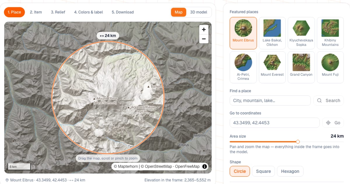
To make a 3D printable terrain model from a map, find a place on the map or enter coordinates, choose a shape (circle, square, hexagon) and an item (tile, pendant, magnet, keychain), then download an STL or 3MF. The terrain relief generator is free and runs in your browser; downloading the file needs a free email sign-in. The area covered by the model is set from 1 to 200 km across.
I built it so that a "mountain souvenir" doesn't require QGIS and Blender. The tool takes elevation and water from open data, and the model itself is built in your browser: only map and place-search requests go to the server.
How do I make a 3D terrain model from a map?
- Place. Find a city, mountain or lake by search, type coordinates like "43.35, 42.44", or click one of the eight featured places. Pan and zoom the map: whatever is inside the frame goes into the model.
- Item. Pick a shape (circle, square, hexagon) and what to print: display tile, pendant with a loop, fridge magnet with a pocket for a real magnet, or keychain.
- Relief. Height exaggeration, smoothing, mesh detail, water.
- Colors and label. Single filament, two colors (land and water) or four by height; the place name and coordinates.
- Download. STL, 3MF or a multicolor 3MF; dimensions, PLA weight and a "Calculate print cost" button.
What can I adjust?
| Setting | Range | Default |
|---|---|---|
| Area (frame width) | 1–200 km | 24 km |
| Shape | circle, square, hexagon | circle |
| Item width | tile 40–220 mm, pendant 20–60, magnet 30–100, keychain 25–70 | tile 100 mm |
| Base thickness | 1.2–10 mm | tile 3 mm, pendant 2, magnet 5, keychain 2.5 |
| Height exaggeration | ×1–10 or auto | auto |
| Smoothing | 0–5 | 1 |
| Mesh detail | fast, normal, detailed (up to 140, 240 and 380 points across) | normal |
| Water depth | 0.4–3 mm | 1 mm |
| Magnet | diameter 5–25 mm, thickness 1–6 mm; the pocket is 0.2 mm wider and deeper | 10 × 3 mm |
| Label | up to 40 characters; on the back (engraved 0.6 mm deep) or a plaque on the front (letters 0.8 mm high) | none |
The loop hole is 3.6 mm in diameter on the pendant and 5.8 mm on the keychain. The base thickens automatically if water, the magnet pocket or a label needs more material underneath, and the tool tells you when it does.
Which places are ready to use?
| Place | Area | Shape | Default colors |
|---|---|---|---|
| Mount Elbrus | 24 km | circle | 4 by height |
| Lake Baikal, Olkhon | 110 km | square | land and water |
| Klyuchevskaya Sopka | 60 km | hexagon | 4 by height |
| Khibiny Mountains | 46 km | square | land and water |
| Ai-Petri, Crimea | 22 km | circle | land and water |
| Mount Everest | 30 km | hexagon | 4 by height |
| Grand Canyon | 26 km | square | 4 by height |
| Mount Fuji | 40 km | circle | 4 by height |
Why exaggerate heights, and what scale should I use?
The model scale is the area width divided by the item width: 24 km on a 100 mm tile means 240 m per millimeter. At that scale real mountains come out low: 2,000 m over a 50 km area is only 4 mm on a 100 mm tile. Height exaggeration lifts the relief so it reads.
Auto mode picks a factor so that the height range in the model is about 14% of the item width (but not less than 2.5 mm and not more than 16 mm); the factor is limited to ×1–10. If the peaks come out too sharp, untick "Pick automatically" and lower the factor; smoothing removes noise.
Choose places with real relief: mountains, river valleys, lakes, islands, coastlines. Cities are almost flat and the tile will come out flat. And don't take an area much larger than the item: 200 km on a 36 mm pendant is about 5.5 km per millimeter, and small details disappear.
How do I print water and heights in different colors?
- Single filament. A regular STL or 3MF, prints in any filament. Water is recessed below the banks, so riverbeds and the shoreline show even without color. The height tint in the preview is just for clarity.
- 2 colors: land and water. Water becomes a separate 0.8 mm part on top of the land, assigned to filament 2 in the 3MF.
- 4 colors by height. The model is cut by horizontal planes into lowlands, hills, mountains and peaks, filaments 1–4. Thresholds are set as a percentage of the relief height (25, 50 and 78% by default) and shown in meters of real elevation. On an AMS that is three filament changes per print. A familiar palette: green lowlands, light brown hills, dark brown mountains, white peaks. In land-and-water mode water is usually blue.
- 3MF format. The "3MF · 2 colors" or "3MF · 4 colors" button exports a Bambu Studio format project: Bambu Studio and OrcaSlicer open the model as parts with filaments already assigned, and you only pick the spools. PrusaSlicer and Cura don't understand this format: use the plain STL and add a filament change at the right height (for 4 colors the threshold heights in millimeters are shown under the button).
For how much filament multicolor prints waste, see AMS purge waste.
How do I print the relief?
- Base down on the bed, no supports needed.
- 0.12–0.16 mm layers: mountain slopes come out smooth.
- 10–15% infill, 2–3 perimeters.
- Pendant: the loop prints together with the base; add the ring after printing.
- Magnet: the pocket is on the underside; glue the magnet in with a drop of glue.
- A back label is engraved 0.6 mm deep and reads when you flip the piece over. Letters on the front plaque stand 0.8 mm high.
Common mistakes
- Picking a city or a plain. The tile comes out flat. Choose mountains, a river or a coast.
- An area far too big for a small item. Details under the 0.4 mm nozzle width won't print.
- Expecting buildings and roads. The model has only elevation and water (rivers, lakes, sea). If rivers are not visible, turn on "Small rivers and streams".
- A tiny label. If letters come out under 2.5 mm the tool warns you: make the item larger or shorten the text. The font covers Latin and Cyrillic; other characters are skipped.
- Opening a colored 3MF in PrusaSlicer or Cura. The filament assignment is lost. Use the STL.
- Selling souvenirs without crediting the sources. The data is open, but with attribution (see below).
Where does the data come from, and can I sell the souvenirs?
Elevation: Mapterhorn (Copernicus GLO-30 and open national datasets, full list at mapterhorn.com/attribution), with AWS Terrain Tiles as a fallback. Rivers, lakes and the map: OpenStreetMap contributors (ODbL), tiles by OpenFreeMap. Place search: Photon and Nominatim. The data generally allows commercial use with attribution, so credit "© OpenStreetMap contributors" and "© Mapterhorn" in the listing or on the packaging. This is not legal advice: read the license terms yourself.
How does it compare with other map-to-STL generators?
Terrain models from a map can be made with Map2Model (STL and multicolor 3MF in the browser), MapsTo3D (STL, 3MF, GLB, OBJ, DXF), Terrain2STL (SRTM data) and others.
- When ours is more convenient: you want a finished souvenir (pendant, magnet, keychain or tile), water and heights in separate colors in a 3MF for Bambu Studio and OrcaSlicer, and a label with the place name and coordinates.
- When something else is better: you need buildings and roads, areas over 200 km, GLB, OBJ or DXF output, or precise survey-grade work. For that, QGIS or Blender with geodata will serve you better.
If the souvenir needs a text caption, try the keychain tag generator or the nameplate generator. To estimate what the finished piece costs, use the print cost calculator.
Frequently asked questions
- How do I make a 3D printable terrain model from a map?
- Open the terrain generator, find a place by search or coordinates or pick a featured one, set an area from 1 to 200 km, choose a shape and an item, check the preview and download an STL or 3MF. Setup is free; downloading needs a free email sign-in.
- Where does the elevation data come from, and how accurate is it?
- From the Mapterhorn digital elevation model: worldwide it is Copernicus GLO-30 at about 30 m resolution, with more detailed national data in some countries. That is plenty for a souvenir, since mountains, valleys and coastlines are instantly recognizable.
- Why do I need height exaggeration on a 3D printed map?
- At model scale real mountains are very low: 2,000 m over a 50 km area is only 4 mm on a 100 mm tile. Exaggeration lifts the relief so it reads well. Auto mode picks a factor between ×1 and ×10 for the area.
- How do I print the water on a map in another color?
- Choose 2 colors: land and water, then download 3MF with 2 colors. Water becomes a separate 0.8 mm layer on top of the land and is assigned to filament 2 in Bambu Studio or OrcaSlicer. Without an AMS, pause and swap filament at the water floor height.
- Can I make a model of my house, cottage or hometown?
- Yes: find the place by search or coordinates, and the frame goes down to 1 km. Keep in mind that cities are almost flat and the model has no buildings or roads. Mountains, river valleys, lakes and coastlines look best.
- Do I need an AMS to print a colored terrain map?
- No. A single-color STL prints on any printer. For 2 or 4 colors without an AMS, download the STL and add filament changes in the slicer at the right heights: for 4 colors the threshold heights are shown under the download button, for water it is the water floor height.
- Can I sell printed map souvenirs?
- The data is open and generally allows commercial use with attribution: OpenStreetMap is licensed under ODbL, Copernicus GLO-30 under the free Copernicus license. Credit © OpenStreetMap contributors and © Mapterhorn in the listing or on the packaging. This is not legal advice, so check the licenses yourself.